


 关联应用
关联应用

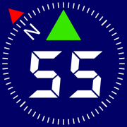
Compass 55. Map & GPS kit.
Land, air, marine navigation
开发者: Kalimex-Consulting s.r.o. @Blocoware & Stanislav Dvoychenko

15天10小时
最新版本上线距今
4
近1年版本更新次数
2016-09-22
全球最早版本上线日期
版本: 4.3
版本更新日期
2024-09-21
Compass 55. Map & GPS kit.
Land, air, marine navigation
更新日志
◆ Optimizations for iOS 18. Supported versions of iOS are now 15-18.应用描述
All-in-one assistant with a map, compass, GPS coordinates to view and share in 6 formats, altitude, distance, sunset/sunrise, speedometer with top and average speed, navigator to your target or along the route and a whole lot more!
+ Advanced target/waypoint editor. Can be also used as a coordinates converter. You can use map to check or set waypoint location and add photo or audio note.
+ Share your location via email, text message, Facebook or Twitter. This includes UTM, MGRS and Latitude/Longitude (MENU>Share my location).
+ You can use UTM, MGRS or Lat/Long, just pick your preference in settings (Coordinate Format).
+ Speedometer. Shows you the speed and pace. Speedometer also gives you options to control average and max speed and pace counters (MENU > RESET and PAUSE/RESUME counters).
+ Compass. Instant reaction compass, no delays. Automatically pickups the direction based on magnetic or GPS course. If you mostly walk or drive, you can change this automatic mode in app settings > Compass or GPS course. NATO mils? Same place in settings to set.
+ Magnetic declination δ for the current location and any location on the map (via World Magnetic Model, WMM, no need for data/internet).
+ Sunset and sunrise. So you can plan your travel better.
+ Arrow pointing to your target waypoint. Distance and bearing to it.
+ Create/measure routes and areas.
+ Barometric Vertical Speed Indicator (VSI, IVSI) in both scale and graph forms.
+ Integration of bluetooth sensors: Cycling cadence, Heart rate, Cycling speed.
All above belong to a basic version. Lifetime PRO Pack upgrade will add following capabilities:
+ Recording and sharing GPS tracks.
+ Moving waypoints between folders.
+ Showing ETA to a target as this requires GPS tracking.
+ Native Google map with fantastic terrain map, amazing 3D and real night mode.
+ Adding own/custom tile map servers.
+ Downloading offline maps. Offline maps import in .sqlitedb, rmaps, mbtiles formats. Support for overzoom and underzoom - offline map is shown even for zoom levels that are not downloaded.
+ GPX import and export for waypoints, tracks and routes.
+ Google Earth KML support for waypoints and tracks import/export. KMZ support for waypoints and tracks export, waypoints import.
+ Ground overlays. Import KMZ ground overlay or draw your own on the map in the app and share as kmz files!
+ CSV import/export for waypoints.
+ Voice coach to tell you active track distance and duration, current speed and altitude without need to open the app.
+ Support for Siri shortcuts in IOS 12 for starting and stopping GPS tracks.
+ From version 4.2 - support for OSGB (including grid shifts) and SK 42 in the coordinates converter.
+ BACKGROUND MODE. App will work in background automatically when tracking. You can use other apps while Compass 55 does its job in the background!
+ PRIVACY. Compass 55 never shares your location data with 3rd parties or ad agencies. Location data is used solely for telling you direction to a target and recording GPS tracks and never leave the app unless you decide to share by means of a track export. It always lets you know when background mode is on and never runs in background unless the track is being recorded.
! You can use this app on your iPhone as well as on any cellular iPad. **App will not work properly on iPods and wifi only iPads as they don't have GPS (external GPS module is required). As quite a lot of us are using external GPS modules, app is available for wifi only iPads and iPods.
! Please note that as with all GPS apps, continued use of GPS running in the background can dramatically decrease battery life.版本: 4.2
版本更新日期
2024-08-14

Compass 55. Map & GPS kit.
Land, air, marine navigation
更新日志
◆ Added a new text input-based coordinates converter. You'll find it in several places:
- MENU > Coordinates converter.
- In the point editor, to the left of the Done button or in the Latitude/Longitude, UTM, MGRS rows.
- On the map, in the map search > Coordinates.
• The new coordinates converter also supports the OSGB and SK 42 coordinate systems, in addition to the current Latitude/Longitude, UTM, and MGRS formats.
• This is part of our ongoing effort to bring support for the majority of EPSG coordinate systems to the app. We hope the new coordinates converter proves to be a useful tool.
• Please let us know via a review or at support@blocoware.com if you'd like to see your preferred coordinate system added.应用描述
All-in-one assistant with a map, compass, GPS coordinates to view and share in 6 formats, altitude, distance, sunset/sunrise, speedometer with top and average speed, navigator to your target or along the route and a whole lot more!
+ Advanced target/waypoint editor. Can be also used as a coordinates converter. You can use map to check or set waypoint location and add photo or audio note.
+ Share your location via email, text message, Facebook or Twitter. This includes UTM, MGRS and Latitude/Longitude (MENU>Share my location).
+ You can use UTM, MGRS or Lat/Long, just pick your preference in settings (Coordinate Format).
+ Speedometer. Shows you the speed and pace. Speedometer also gives you options to control average and max speed and pace counters (MENU > RESET and PAUSE/RESUME counters).
+ Compass. Instant reaction compass, no delays. Automatically pickups the direction based on magnetic or GPS course. If you mostly walk or drive, you can change this automatic mode in app settings > Compass or GPS course. NATO mils? Same place in settings to set.
+ Magnetic declination δ for the current location and any location on the map (via World Magnetic Model, WMM, no need for data/internet).
+ Sunset and sunrise. So you can plan your travel better.
+ Arrow pointing to your target waypoint. Distance and bearing to it.
+ Create/measure routes and areas.
+ Barometric Vertical Speed Indicator (VSI, IVSI) in both scale and graph forms.
+ Integration of bluetooth sensors: Cycling cadence, Heart rate, Cycling speed.
All above belong to a basic version. Lifetime PRO Pack upgrade will add following capabilities:
+ Recording and sharing GPS tracks.
+ Moving waypoints between folders.
+ Showing ETA to a target as this requires GPS tracking.
+ Native Google map with fantastic terrain map, amazing 3D and real night mode.
+ Adding own/custom tile map servers.
+ Downloading offline maps. Offline maps import in .sqlitedb, rmaps, mbtiles formats. Support for overzoom and underzoom - offline map is shown even for zoom levels that are not downloaded.
+ GPX import and export for waypoints, tracks and routes.
+ Google Earth KML support for waypoints and tracks import/export. KMZ support for waypoints and tracks export, waypoints import.
+ Ground overlays. Import KMZ ground overlay or draw your own on the map in the app and share as kmz files!
+ CSV import/export for waypoints.
+ Voice coach to tell you active track distance and duration, current speed and altitude without need to open the app.
+ Support for Siri shortcuts in IOS 12 for starting and stopping GPS tracks.
+ From version 4.2 - support for OSGB (including grid shifts) and SK 42 in the coordinates converter.
+ BACKGROUND MODE. App will work in background automatically when tracking. You can use other apps while Compass 55 does its job in the background!
+ PRIVACY. Compass 55 never shares your location data with 3rd parties or ad agencies. Location data is used solely for telling you direction to a target and recording GPS tracks and never leave the app unless you decide to share by means of a track export. It always lets you know when background mode is on and never runs in background unless the track is being recorded.
! You can use this app on your iPhone as well as on any cellular iPad. **App will not work properly on iPods and wifi only iPads as they don't have GPS (external GPS module is required). As quite a lot of us are using external GPS modules, app is available for wifi only iPads and iPods.
! Please note that as with all GPS apps, continued use of GPS running in the background can dramatically decrease battery life.版本: 4.1
版本更新日期
2024-06-28
Compass 55. Map & GPS kit.
Land, air, marine navigation
更新日志
◆ You can now change the color of buttons in the app. This should provide more options for improved visibility of buttons in bright sunlight and potentially assist in cases involving color vision deficiencies.) Settings > Button colors.
◆ Google maps updated to version 9.0.0.
◆ Bug fixes and optimizations:
‣ Fixed intermittent crash when asking for confirmation if you want to stop the offline map download screen on closing the download screen while download is in progress when the choice was to continue with the download.
‣ Fixed rare crash when opening the map settings.应用描述
暂无应用描述数据
版本: 4.0
版本更新日期
2024-05-15

Compass 55. Map & GPS kit.
Land, air, marine navigation
更新日志
◆ Overzoom and underzoom for offline maps:
‣ Allows to show the offline map for zoom levels that are not downloaded or imported.
‣ With overzoom you can download zoom level 2-16 and let the map upscale from zoom level 16 to 17-19 as you zoom in.
‣ Overzoom and underzoom is applied automatically, no need to set up anything.
‣ For the best experience with offline or custom/blank maps on iOS 16, please be sure to have iOS 16.4 or later.
◆ Improvements for land navigation:
‣ New automatic check-in option that allows to check-in by simply entering the circle around the target.
‣ Settings button in the 'Set Target' menu now opens the land navigation settings screen.
‣ 'Set Target' menu now shows information on navigation settings.
‣ Both Estimated Time En Route (ETE) and Estimated Time of Arrival (ETA) are now supported for land/air navigation targets. Tap on ETE display to switch to ETA and vice versa.
◆ Track list improvements. MENU > Tracks:
‣ Track list now shows total mileage and duration for each day with tracks recorded.
‣ Applied filter, number of shown tracks and their total distance is now shown at the bottom of the track list.
‣ Added option to search/filter by text.
‣ When track note is shown in the tracks list, you can tap on a note button to edit track fields: name, note, start/end address.
◆ You can now trim recorded track at its end.
◆ Points list now shows a footer with help and description for the applied filter and sort order, so there is no confusion for what and why is shown in the list.
◆ First iteration on integration with bluetooth sensors:
‣ Heart rate
‣ Cycling speed
‣ Cycling cadence
- Can be useful for cyclists or custom bike/vehicle builders.
- Completely optional. Available for iOS 17 and higher.
- If you want to connect bluetooth sensors, swipe through on the bottom (in portrait) or left (in landscape) panel until you see the new bluetooth sensors panel. Or use ⋮ button in the bottom or left panel to show the new bluetooth panel.
◆ Camera tool:
‣ You can now re-apply comments from existing points/photos to fill all manual comment fields for the new photo, at once. Should give a productivity boost for re-inspections. It's a new bottom section in the comments editor screen.
‣ Removed full swipe delete gesture in the list of photos as it was causing unwanted deletes. Thank you for the feedback! You can still delete by swipe, but need to swipe and then tap on the delete button.
‣ Scanner section is added to the photo notes editor. Scanner allows to extract lines of text from QR, barcode or texts and assign them to the note fields.
‣ Now you can configure the automatic photo title that goes far beyond the timestamp. Combine collection name, timestamp, custom text and auto increment number in any way that suits best your work or project. Timestamp still stays as a default automatic photo title.
‣ When viewing saved photos, the app now remembers if your last view choice was the original photo or stamped. No need to switch to the stamped view everytime, your preference is now remembered.
- If this breaks your current workflow anyhow, you can configure different viewing preferences. Settings > Viewing saved photos.
‣ When you open photo from the points list, the app now provides controls to navigate through the adjacent photos in the points list, without the need to return to the list. You can swipe through or use left/right arrows.
◆ Google maps updated to version 8.4.0.
◆ Removed support for iOS 12-14. Supported iOS versions are now 15, 16, 17. You can still install older app versions on the devices with older iOS versions.
◆ From iOS 17.5, barometer related functions require access to 'Motion & Fitness'. The app now provides visual hints to enable the access, where required.应用描述
All-in-one assistant with a map, compass, GPS coordinates to view and share in 6 formats, altitude, distance, sunset/sunrise, speedometer with top and average speed, navigator to your target or along the route and a whole lot more!
+ Advanced target/waypoint editor. Can be also used as a coordinates converter. You can use map to check or set waypoint location and add photo or audio note.
+ Share your location via email, text message, Facebook or Twitter. This includes UTM, MGRS and Latitude/Longitude (MENU>Share my location).
+ You can use UTM, MGRS or Lat/Long, just pick your preference in settings (Coordinate Format).
+ Speedometer. Shows you the speed and pace. Speedometer also gives you options to control average and max speed and pace counters (MENU > RESET and PAUSE/RESUME counters).
+ Compass. Instant reaction compass, no delays. Automatically pickups the direction based on magnetic or GPS course. If you mostly walk or drive, you can change this automatic mode in app settings > Compass or GPS course. NATO mils? Same place in settings to set.
+ Magnetic declination δ for the current location and any location on the map (via World Magnetic Model, WMM, no need for data/internet).
+ Sunset and sunrise. So you can plan your travel better.
+ Arrow pointing to your target waypoint. Distance and bearing to it.
+ Create/measure routes and areas.
+ Barometric Vertical Speed Indicator (VSI, IVSI) in both scale and graph forms.
+ Integration of bluetooth sensors: Cycling cadence, Heart rate, Cycling speed.
All above belong to a basic version. Lifetime PRO Pack upgrade will add following capabilities:
+ Recording and sharing GPS tracks.
+ Moving waypoints between folders.
+ Showing ETA to a target as this requires GPS tracking.
+ Native Google map with fantastic terrain map, amazing 3D and real night mode.
+ Adding own/custom tile map servers.
+ Downloading offline maps. Offline maps import in .sqlitedb, rmaps, mbtiles formats. Support for overzoom and underzoom - offline map is shown even for zoom levels that are not downloaded.
+ GPX import and export for waypoints, tracks and routes.
+ Google Earth KML support for waypoints and tracks import/export. KMZ support for waypoints and tracks export, waypoints import.
+ Ground overlays. Import KMZ ground overlay or draw your own on the map in the app and share as kmz files!
+ CSV import/export for waypoints.
+ Voice coach to tell you active track distance and duration, current speed and altitude without need to open the app.
+ Support for Siri shortcuts in IOS 12 for starting and stopping GPS tracks.
+ BACKGROUND MODE. App will work in background automatically when tracking. You can use other apps while Compass 55 does its job in the background!
+ PRIVACY. Compass 55 never shares your location data with 3rd parties or ad agencies. Location data is used solely for telling you direction to a target and recording GPS tracks and never leave the app unless you decide to share by means of a track export. It always lets you know when background mode is on and never runs in background unless the track is being recorded.
! You can use this app on your iPhone as well as on any cellular iPad. **App will not work properly on iPods and wifi only iPads as they don't have GPS (external GPS module is required). As quite a lot of us are using external GPS modules, app is available for wifi only iPads and iPods.
! Please note that as with all GPS apps, continued use of GPS running in the background can dramatically decrease battery life.版本: 3.4
版本更新日期
2022-08-10

Compass 55. Map & GPS kit.
Land, air, marine navigation
更新日志
◆ Length annotations can now show line direction as azimuth or U.S. land survey bearing. Settings > Map Settings > Common settings > Annotations > Angle.
◆ Ground Image Overlays: Added limited support for kml gx:LatLonQuad overlays (including export).应用描述
All-in-one assistant with a map, compass, GPS coordinates to view and share in 6 formats, altitude, distance, sunset/sunrise, speedometer with top and average speed, navigator to your target or along the route and a whole lot more!
+ Advanced target/waypoint editor. Can be also used as a coordinates converter. You can use map to check or set waypoint location and add photo or audio note.
+ Share your location via email, text message, Facebook or Twitter. This includes UTM, MGRS and Latitude/Longitude (MENU>Share my location).
+ You can use UTM, MGRS or Lat/Long, just pick your preference in settings (Coordinate Format).
+ Speedometer. Shows you the speed and pace. Speedometer also gives you options to control average and max speed and pace counters (MENU > RESET and PAUSE/RESUME counters).
+ Compass. Instant reaction compass, no delays. Automatically pickups the direction based on magnetic or GPS course. If you mostly walk or drive, you can change this automatic mode in app settings > Compass or GPS course. NATO mils? Same place in settings to set.
+ Magnetic declination δ for the current location and any location on the map (via World Magnetic Model, WMM, no need for data/internet).
+ Sunset and sunrise. So you can plan your travel better.
+ Arrow pointing to your target waypoint. Distance and bearing to it.
+ Create/measure routes and areas.
+ Barometric Vertical Speed Indicator (VSI, IVSI) in both scale and graph forms.
All above belong to a basic version. PRO Pack upgrade will add following capabilities:
+ Recording and sharing GPS tracks.
+ Moving waypoints between folders.
+ Showing ETA to a target as this requires GPS tracking.
+ Native Google map with fantastic terrain map, amazing 3D and real night mode.
+ Adding own/custom tile map servers.
+ Downloading offline maps. Offline maps import in .sqlitedb, rmaps, mbtiles formats.
+ GPX import and export for waypoints, tracks and routes.
+ Google Earth KML support for waypoints and tracks import/export. KMZ support for waypoints and tracks export, waypoints import.
+ CSV import/export for waypoints.
+ Voice coach to tell you active track distance and duration, current speed and altitude without need to open the app.
+ Support for Siri shortcuts in IOS 12 for starting and stopping GPS tracks.
+ BACKGROUND MODE. App will work in background automatically when tracking. You can use other apps while Compass 55 does its job in the background!
+ PRIVACY. Compass 55 never shares your location data with 3rd parties or ad agencies. Location data is used solely for telling you direction to a target and recording GPS tracks and never leave the app unless you decide to share by means of a track export. It always lets you know when background mode is on and never runs in background unless the track is being recorded.
! You can use this app on your iPhone as well as on any cellular iPad. **App will not work properly on iPods and wifi only iPads as they don't have GPS (external GPS module is required). As quite a lot of us are using external GPS modules, app is available for wifi only iPads and iPods.
! Please note that as with all GPS apps, continued use of GPS running in the background can dramatically decrease battery life.版本: 3.3
版本更新日期
2022-06-05

Compass 55. Map & GPS kit.
Land, air, marine navigation
更新日志
◆ Google maps updated to version 6.2.1.
◆ Amazing new feature in this version: Ground Image Overlays!
• The app can import image overlays from kmz (GroundOverlay).
• You can also take map snapshots in the app (use the button with the compass for this) and save them as image overlays.
• You can draw on top of the image overlays to turn them into tactical plans or add fast freehand annotations.
• Image overlays can be exported as kmz files to open in any compatible app or Google Earth.
◆ You can now order point collections manually and newest collections are shown on top by default. MENU > WAYPOINT COLLECTIONS > Edit.应用描述
All-in-one assistant with a map, compass, GPS coordinates to view and share in 6 formats, altitude, distance, sunset/sunrise, speedometer with top and average speed, navigator to your target or along the route and a whole lot more!
+ Advanced target/waypoint editor. Can be also used as a coordinates converter. You can use map to check or set waypoint location and add photo or audio note.
+ Share your location via email, text message, Facebook or Twitter. This includes UTM, MGRS and Latitude/Longitude (MENU>Share my location).
+ You can use UTM, MGRS or Lat/Long, just pick your preference in settings (Coordinate Format).
+ Speedometer. Shows you the speed and pace. Speedometer also gives you options to control average and max speed and pace counters (MENU > RESET and PAUSE/RESUME counters).
+ Compass. Instant reaction compass, no delays. Automatically pickups the direction based on magnetic or GPS course. If you mostly walk or drive, you can change this automatic mode in app settings > Compass or GPS course. NATO mils? Same place in settings to set.
+ Magnetic declination δ for the current location and any location on the map (via World Magnetic Model, WMM, no need for data/internet).
+ Sunset and sunrise. So you can plan your travel better.
+ Arrow pointing to your target waypoint. Distance and bearing to it.
+ Create/measure routes and areas.
+ Barometric Vertical Speed Indicator (VSI, IVSI) in both scale and graph forms.
All above belong to a basic version. PRO Pack upgrade will add following capabilities:
+ Recording and sharing GPS tracks.
+ Moving waypoints between folders.
+ Showing ETA to a target as this requires GPS tracking.
+ Native Google map with fantastic terrain map, amazing 3D and real night mode.
+ Adding own/custom tile map servers.
+ Downloading offline maps. Offline maps import in .sqlitedb, rmaps, mbtiles formats.
+ GPX import and export for waypoints, tracks and routes.
+ Google Earth KML support for waypoints and tracks import/export. KMZ support for waypoints and tracks export, waypoints import.
+ CSV import/export for waypoints.
+ Voice coach to tell you active track distance and duration, current speed and altitude without need to open the app.
+ Support for Siri shortcuts in IOS 12 for starting and stopping GPS tracks.
+ BACKGROUND MODE. App will work in background automatically when tracking. You can use other apps while Compass 55 does its job in the background!
+ PRIVACY. Compass 55 never shares your location data with 3rd parties or ad agencies. Location data is used solely for telling you direction to a target and recording GPS tracks and never leave the app unless you decide to share by means of a track export. It always lets you know when background mode is on and never runs in background unless the track is being recorded.
! You can use this app on your iPhone as well as on any cellular iPad. **App will not work properly on iPods and wifi only iPads as they don't have GPS (external GPS module is required). As quite a lot of us are using external GPS modules, app is available for wifi only iPads and iPods.
! Please note that as with all GPS apps, continued use of GPS running in the background can dramatically decrease battery life.版本: 3.2
版本更新日期
2022-02-20

Compass 55. Map & GPS kit.
Land, air, marine navigation
更新日志
◆ Import of a photo from the photo library for the waypoint now correctly imports .heic photos.
◆ Google maps updated to version 6.0.1.
◆ Tracks list screen now includes small map previews for the tracks. You can opt out of generating map previews in GPS Tracking settings.
◆ In addition to month-year filtering, you can now filter tracks by the year.
◆ Improved import for big KML/KMZ files/objects.应用描述
All-in-one assistant with a map, compass, GPS coordinates to view and share in 6 formats, altitude, distance, sunset/sunrise, speedometer with top and average speed, navigator to your target or along the route and a whole lot more!
+ Advanced target/waypoint editor. Can be also used as a coordinates converter. You can use map to check or set waypoint location and add photo or audio note.
+ Share your location via email, text message, Facebook or Twitter. This includes UTM, MGRS and Latitude/Longitude (MENU>Share my location).
+ You can use UTM, MGRS or Lat/Long, just pick your preference in settings (Coordinate Format).
+ Speedometer. Shows you the speed and pace. Speedometer also gives you options to control average and max speed and pace counters (MENU > RESET and PAUSE/RESUME counters).
+ Compass. Instant reaction compass, no delays. Automatically pickups the direction based on magnetic or GPS course. If you mostly walk or drive, you can change this automatic mode in app settings > Compass or GPS course. NATO mils? Same place in settings to set.
+ Magnetic declination δ for the current location and any location on the map (via World Magnetic Model, WMM, no need for data/internet).
+ Sunset and sunrise. So you can plan your travel better.
+ Arrow pointing to your target waypoint. Distance and bearing to it.
+ Create/measure routes and areas.
+ Barometric Vertical Speed Indicator (VSI, IVSI) in both scale and graph forms.
All above belong to a basic version. PRO Pack upgrade will add following capabilities:
+ Recording and sharing GPS tracks.
+ Moving waypoints between folders.
+ Showing ETA to a target as this requires GPS tracking.
+ Native Google map with fantastic terrain map, amazing 3D and real night mode.
+ Adding own/custom tile map servers.
+ Downloading offline maps. Offline maps import in .sqlitedb, rmaps, mbtiles formats.
+ GPX import and export for waypoints, tracks and routes.
+ Google Earth KML support for waypoints and tracks import/export. KMZ support for waypoints and tracks export, waypoints import.
+ CSV import/export for waypoints.
+ Voice coach to tell you active track distance and duration, current speed and altitude without need to open the app.
+ Support for Siri shortcuts in IOS 12 for starting and stopping GPS tracks.
+ BACKGROUND MODE. App will work in background automatically when tracking. You can use other apps while Compass 55 does its job in the background!
+ PRIVACY. Compass 55 never shares your location data with 3rd parties or ad agencies. Location data is used solely for telling you direction to a target and recording GPS tracks and never leave the app unless you decide to share by means of a track export. It always lets you know when background mode is on and never runs in background unless the track is being recorded.
! You can use this app on your iPhone as well as on any cellular iPad. **App will not work properly on iPods and wifi only iPads as they don't have GPS (external GPS module is required). As quite a lot of us are using external GPS modules, app is available for wifi only iPads and iPods.
! Please note that as with all GPS apps, continued use of GPS running in the background can dramatically decrease battery life.版本: 3.1
版本更新日期
2021-09-25
Compass 55. Map & GPS kit.
Land, air, marine navigation
更新日志
・Optimized for iOS 15.
・Google maps updated to version 5.1.0.
・Added help for individual counters reset in the trip editor.
・MENU > TRIPS: Menu button now shows the active trip name.
◆ MENU > NEW TRACK:
・Menu button now shows current tracking settings and includes a settings button to change these settings.
◆ MENU > WAYPOINT COLLECTIONS:
・Shows the default collection name.
◆ Changes to GPS tracking workflow:
・You can now change the active trip while tracking. The app will ask if you want to create a new track under the newly active trip.应用描述
暂无应用描述数据
版本: 3.0
版本更新日期
2021-07-08
Compass 55. Map & GPS kit.
Land, air, marine navigation
更新日志
◆ Point collections:
・MENU > POINT COLLECTIONS. Tap on a collection row now shows collection action menu.
・The above mentioned menu adds option to clone the whole collection.
◆ Camera, photo and audio attachments:
・Added option to pick the camera device/type for iPhones/iPads with multiple cameras.
・Manual exposure adjustment now uses target exposure bias. This should correspond to how exposure adjustment works in the stock camera app.
◆ Other improvements and fixes:
・Triangle map cursor is now bigger and has white border added.
◆ Removed support for iOS 9-11.应用描述
All-in-one assistant with a map, compass, GPS coordinates to view and share in 6 formats, altitude, distance, sunset/sunrise, speedometer with top and average speed, navigator to your target or along the route and a whole lot more!
+ Advanced target/waypoint editor. Can be also used as a coordinates converter. You can use map to check or set waypoint location and add photo or audio note.
+ Share your location via email, text message, Facebook or Twitter. This includes UTM, MGRS and Latitude/Longitude (MENU>Share my location).
+ You can use UTM, MGRS or Lat/Long, just pick your preference in settings (Coordinate Format).
+ Speedometer. Shows you the speed and pace. Speedometer also gives you options to control average and max speed and pace counters (MENU > RESET and PAUSE/RESUME counters).
+ Compass. Instant reaction compass, no delays. Automatically pickups the direction based on magnetic or GPS course. If you mostly walk or drive, you can change this automatic mode in app settings > Compass or GPS course. NATO mils? Same place in settings to set.
+ Magnetic declination δ for the current location and any location on the map (via World Magnetic Model, WMM, no need for data/internet).
+ Sunset and sunrise. So you can plan your travel better.
+ Arrow pointing to your target waypoint. Distance and bearing to it.
+ Create/measure routes and areas.
+ Barometric Vertical Speed Indicator (VSI, IVSI) in both scale and graph forms.
All above belong to a basic version. PRO Pack upgrade will add following capabilities:
+ Recording and sharing GPS tracks.
+ Moving waypoints between folders.
+ Showing ETA to a target as this requires GPS tracking.
+ Native Google map with fantastic terrain map, amazing 3D and real night mode.
+ Adding own/custom tile map servers.
+ Downloading offline maps. Offline maps import in .sqlitedb, rmaps, mbtiles formats.
+ GPX import and export for waypoints, tracks and routes.
+ Google Earth KML support for waypoints and tracks import/export. KMZ support for waypoints and tracks export, waypoints import.
+ CSV import/export for waypoints.
+ Voice coach to tell you active track distance and duration, current speed and altitude without need to open the app.
+ Support for Siri shortcuts in IOS 12 for starting and stopping GPS tracks.
+ BACKGROUND MODE. App will work in background automatically when tracking. You can use other apps while Compass 55 does its job in the background!
+ PRIVACY. Compass 55 never shares your location data with 3rd parties or ad agencies. Location data is used solely for telling you direction to a target and recording GPS tracks and never leave the app unless you decide to share by means of a track export. It always lets you know when background mode is on and never runs in background unless the track is being recorded.
! You can use this app on your iPhone as well as on any cellular iPad. **App will not work properly on iPods and wifi only iPads as they don't have GPS (external GPS module is required). As quite a lot of us are using external GPS modules, app is available for wifi only iPads and iPods.
! Please note that as with all GPS apps, continued use of GPS running in the background can dramatically decrease battery life.版本: 2.3
版本更新日期
2021-05-11

Compass 55. Map & GPS kit.
Land, air, marine navigation
更新日志
◆Optimized for iOS 14.5.
◆Import/Export:
・The app should now always be offered as 'Open In' option for GPX files.
・Tracks (gx:track and Geometry) can now be imported from KMZ files (only one kml file is supported inside the kmz archive, but it may contain multiple tracks).
・Added GPX export option for the whole trip export (with all tracks). Please note that empty tracks are not exported as Garmin Connect can't import empty tracks anyway. GPX export also generates quite bigger files, compared to KMZ.
・New option to convert route point collection to a track.
◆Point editor:
・Note text field is moved to its own section at the bottom of a point editor screen.
・Point notes now support multiple lines.
・Fixed the bug in point editor when subsequent record/play sessions would play the first recording played, not the most recently recorded audio note.
◆Offline and custom maps:
・Fixed crash when selecting offline map area in iOS 9.
・Refreshed Custom map source editor screen.
◆Voice coach:
・Fixed an issue when new voice coach can't be added after deleting all existing voice coaches.
◆Camera, photo and audio attachments:
・Using downscaled image thumbnails where image previews are shown, e.g. in the points list.
◆Other improvements and fixes:
・New Maintenance screen in the settings allows to delete temporary files in the app.
・All import/export and sharing operations were reviewed to only create temporary files in the system's temporary folder that is being cleaned by iOS automatically after some period of time.应用描述
All-in-one assistant with a map, compass, GPS coordinates to view and share in 6 formats, altitude, distance, sunset/sunrise, speedometer with top and average speed, navigator to your target or along the route and a whole lot more!
+ Advanced target/waypoint editor. Can be also used as a coordinates converter. You can use map to check or set waypoint location and add photo or audio note.
+ Share your location via email, text message, Facebook or Twitter. This includes UTM, MGRS and Latitude/Longitude (MENU>Share my location).
+ You can use UTM, MGRS or Lat/Long, just pick your preference in settings (Coordinate Format).
+ Speedometer. Shows you the speed and pace. Speedometer also gives you options to control average and max speed and pace counters (MENU > RESET and PAUSE/RESUME counters).
+ Compass. Instant reaction compass, no delays. Automatically pickups the direction based on magnetic or GPS course. If you mostly walk or drive, you can change this automatic mode in app settings > Compass or GPS course. NATO mils? Same place in settings to set.
+ Magnetic declination δ for the current location and any location on the map (via World Magnetic Model, WMM, no need for data/internet).
+ Sunset and sunrise. So you can plan your travel better.
+ Arrow pointing to your target waypoint. Distance and bearing to it.
+ Create/measure routes and areas.
+ Barometric Vertical Speed Indicator (VSI, IVSI) in both scale and graph forms.
All above belong to a basic version. PRO Pack upgrade will add following capabilities:
+ Recording and sharing GPS tracks.
+ Moving waypoints between folders.
+ Showing ETA to a target as this requires GPS tracking.
+ Native Google map with fantastic terrain map, amazing 3D and real night mode.
+ Adding own/custom tile map servers.
+ Downloading offline maps. Offline maps import in .sqlitedb, rmaps, mbtiles formats.
+ GPX import and export for waypoints, tracks and routes.
+ Google Earth KML support for waypoints and tracks import/export. KMZ support for waypoints and tracks export, waypoints import.
+ CSV import/export for waypoints.
+ Voice coach to tell you active track distance and duration, current speed and altitude without need to open the app.
+ Support for Siri shortcuts in IOS 12 for starting and stopping GPS tracks.
+ BACKGROUND MODE. App will work in background automatically when tracking. You can use other apps while Compass 55 does its job in the background!
+ PRIVACY. Compass 55 never shares your location data with 3rd parties or ad agencies. Location data is used solely for telling you direction to a target and recording GPS tracks and never leave the app unless you decide to share by means of a track export. It always lets you know when background mode is on and never runs in background unless the track is being recorded.
! You can use this app on your iPhone as well as on any cellular iPad. **App will not work properly on iPods and wifi only iPads as they don't have GPS (external GPS module is required). As quite a lot of us are using external GPS modules, app is available for wifi only iPads and iPods.
! Please note that as with all GPS apps, continued use of GPS running in the background can dramatically decrease battery life.


微信公众号

七麦数据公众号

七麦研究院公众号
APP下载
- IOS
- Android

@2014-2022 qimai.cn,北京七麦科技股份有限公司 All Rights Reserved. 京ICP备14049953号
 京公网安备 11010502041000号


